Current State
Seasonal snow accumulation and melt are crucial because of their strong impact on the hydrological cycle. A considerable percentage of the total water supply is linked to snow stored during winter and released in spring during the melting season, especially in mountainous regions, where snowmelt runoff generally contributes up to at least 50 to 95 percent of the total flow (Shafer et al., 1982). The predictability of snow contribution to the total streamflow is essential for flood event forecasting and for a correct planning of human activities such as agriculture irrigation, drinking water supply and hydropower production (Beniston et al., 2018). However, recent trends have shown how increasing winter temperatures cause a decline of accumulation and an early snowmelt in the spring (Beniston, 2012; Bavay, 2013; Matiu et al., 2021, Carletti et al., 2022). Therefore, snowmelt monitoring and forecasting is essential for a proactive management of the water resources.
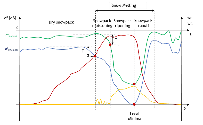
Snowmelt is an energy driven process which results in the release of the melt water from the snowpack. Three different phases can be distinguished (Dingman, 2015):
- Moistening: first warming of the snowpack enhanced by liquid water infiltration from rain or surface melting;
- Ripening: the snowpack has reached an isothermal state at 0°C and holds liquid water;
- Runoff: melt and additional water stored in the snowpack are released.
The most significant state variables to properly identify the three melting phases are:
- Snow Water Equivalent (SWE): the total mass of snow cover including liquid and solid phases;
- Liquid water content (LWC): the mass percentage of liquid water contained in the snowpack.
Continuous assessment of SWE and LWC is therefore essential to monitor the snowpack melting dynamics. However, these observations are scarcely available and are time consuming, costly and potentially expose operators to avalanche dangers. To mitigate these limitations, energy- and physically-based, multilayer snow models can simulate SWE and LWC at high spatial and temporal resolution (e.g., Lehning et al., 2006, Wever et al., 2015, Vionnet et al., 2012, Strasser et al., 2011, Endrizzi et al., 2014).
However, model complexity can lead to overparameterized, computationally demanding models (Ratto et al., 2012) and equifinality problems (Beven & Freer, 2001). Model performances are affected by uncertainties and errors related mainly to model structure and inaccurate meteorological forcings, which are difficult to distribute in complex terrain (Engel et al., 2017; Günther et al., 2019). Therefore, there is a need for snow observations with high temporal and spatial resolution, distributed over a large area and acquired systematically.
The introduction of the new family of Sentinel missions operated by the European Space Agency (ESA) opened new opportunities for the monitoring of snowmelt. In detail, the Sentinel-1 (S-1) mission is composed of a constellation of two satellites with a C-band SAR mounted on board. Images, with a nominal resolution of 20 m, are regularly acquired every 6 days in dual-polarization over Europe. The Sentinel-2 (S-2) constellation is made up of two twin satellites operating a multispectral sensor with 13 bands in the visible, near infrared, and short-wave infrared part of the spectrum. The revisit time is about 5 days at the equator and the spatial resolution varies from 10 m to 60 m.
Microwave systems are inherently sensitive to the presence of LWC in the snowpack, which is why several works to retrieve snow melting properties by using SAR have been presented in the literature (e.g. Shi & Dozier 1995, Nagler & Rott 2000, Longepe et al. 2009, Ulaby et al., 1981). In particular, dry snow is almost transparent to the SAR sensor at C-band, which is the working frequency of S-1, meanwhile the presence of water in the snowpack causes high dielectric losses. The changes in the electromagnetic properties of the snowpack linked to an increase in LWC can be detected by observing the backscattering coefficient of wet snow in contrast to the backscattering from dry snowpack (Baghdadi et al., 1997, Nagler & Rott, 2000).
However, at the best of our knowledge only Marin et al. (2020) attempted to identify the three phases of snowmelt and made a first attempt to derive a time map for the runoff onset for a high-altitude catchment scale. In particular, their work focused on the relationship between the multi-temporal SAR backscattering and the snow melting phases, i.e., moistening, ripening and runoff (Figure 1).
Despite the promising results, the main challenge is represented by the difficulties to fully understand the backscattering behaviour with respect to snow metamorphism during the melting period. This is mainly due to the lack of snowpack information collected at the same time of the SAR acquisitions. In fact, even though wet snow is of great importance for hydrology, the direct snow observations generally stop when the maximum of SWE is reached. This led to focus on the EM interactions with the microstructure of the snow (i.e., layering and size and distribution of the snow grains) in dry snow conditions allowing the development of Radiative Transfer Models (RTMs) able to describe the behaviour of passive and active radars working at a wide range of frequencies. On the other side, the studies on wet snow only partially considered the effects of the wet snow metamorphism to the backscattering at the different microwave frequencies.
Moreover, the capability of S-1 to observe snow properties over large areas at high spatial resolution (~20 m) could be very beneficial for having spatial data to validate and improve distributed physically-based snow and hydrological models.
The most relevant preliminary result for this proposal is the recent paper of Marin et al. (2020), who found a relationship between the multi-temporal SAR backscattering and the different snow melting phases, showing very promising opportunities for an early and spatially accurate detection of snowmelt processes in mountainous regions. Despite the promising results, the main challenge is represented by the difficulty to fully understand the backscattering behaviour with respect to wet snow metamorphism during the melting period. A better understanding of these processes through in situ observations in wet-snow conditions motivates this project, together with the ambition to start exploring the applied potential for water resource management of integrating radar remote sensing and hydrological models.